Welcome to EPS Field School 2019!

Taught by: Christie Rowe, christie.rowe[at]mcgill.ca
Office: FDA 402; 514-398-2769

Teaching assistants: Samantha Carruthers, Caroline Seyler, Nick Ogasa

This is the website for two courses. General information for both courses is at the top, follow the links below for the Course Outlines for the individual courses.

Field School 1 (EPSC231) is an introductory field mapping course for undergraduates. The best prerequisite to have is EPSC240: Geology in the Field but we will also draw on course content from Structural Geology (EPSC203), Petrology (EPSC212) and any introductory earth history course (e.g. EPSC201, ESYS104, EPSC181, EPSC199, EPSC221, EPSC233). If you are worried about your level of preparedness, please email the instructor to discuss.

Tectonics in the Field (EPSC645 Topics) is an experiment this year, to provide mapping experience for graduate students. In addition to mapping projects in the field which will overlap somewhat with the assignments for EPSC231, the EPSC645 students will meet monthly during winter semester to discuss journal articles focused on the regional tectonic history of the Mojave and Basin & Range (EPSC231 students are invited but not required to attend these discussions). In addition, EPSC645 students will present a poster in the field on a topic of their choosing related to the regional geologic history.


Everybody: + Geology + Itinerary + Helpful Links + Travel + What to Wear + What to Bring + Varia +
EPSC231: + Overview + Learning Outcomes + Instructional Method + Materials + Content + Evaluation +
EPSC645: + Overview + Learning Outcomes + Instructional Method + Materials + Content + Evaluation +

Geologic History

The core of North America consists of old (Archean-Proterozoic) metamorphosed rock including supracrustals (sediments and volcanics) and orthogneisses (intrusive igneous rocks). These rocks are often referred to as 'basement' because they are unconformably overlain in most areas by younger rock. They are diverse but mostly covered, only exposed where blocks of crust have been tectonically uplifted so that the cover eroded away. Much argument is devoted to matching these rocks to other continents to understand the linkages across earlier supercontinental cycles.

From the late Proterozoic until near the end of the Paleozoic, the western margin of North America was a wide shallow continental shelf with little or no tectonic activity (passive margin). Steady sedimentation (clastic and carbonate) built up a thick sequence of sediments containing fossils which record the Cambrian Explosion!

Tectonic activity began in the late Paleozoic and a series of collisions brought new terranes to the North American margin and resulted in shortening of the platform sediments. Subduction initiated in the middle Mesozoic. Western North America rose above sea level and sedimentation changed from marine to subaerial. Arc-related and plate-reorganization-related magmatic activity produced the 148 Ma Independence Dike Swarm and lots of small plutons which contributed to ore deposit formation in the eastern Sierra. The Keystone-Muddy Mountain Thrust system developed during the late Cretaceous Sevier Orogeny and shallowly thrust older marine rocks inland (eastward) over the Mesozoic continental sediments. Steeper reverse faults took over from low angle thrusts in some areas, indicating a change in orogenic style called the Laramide Orogeny. Laramide uplifts revealed Proterozoic crystalline rocks in some of the mountain ranges. The early part of the Cenozoic was not well recorded in the rocks of the region.


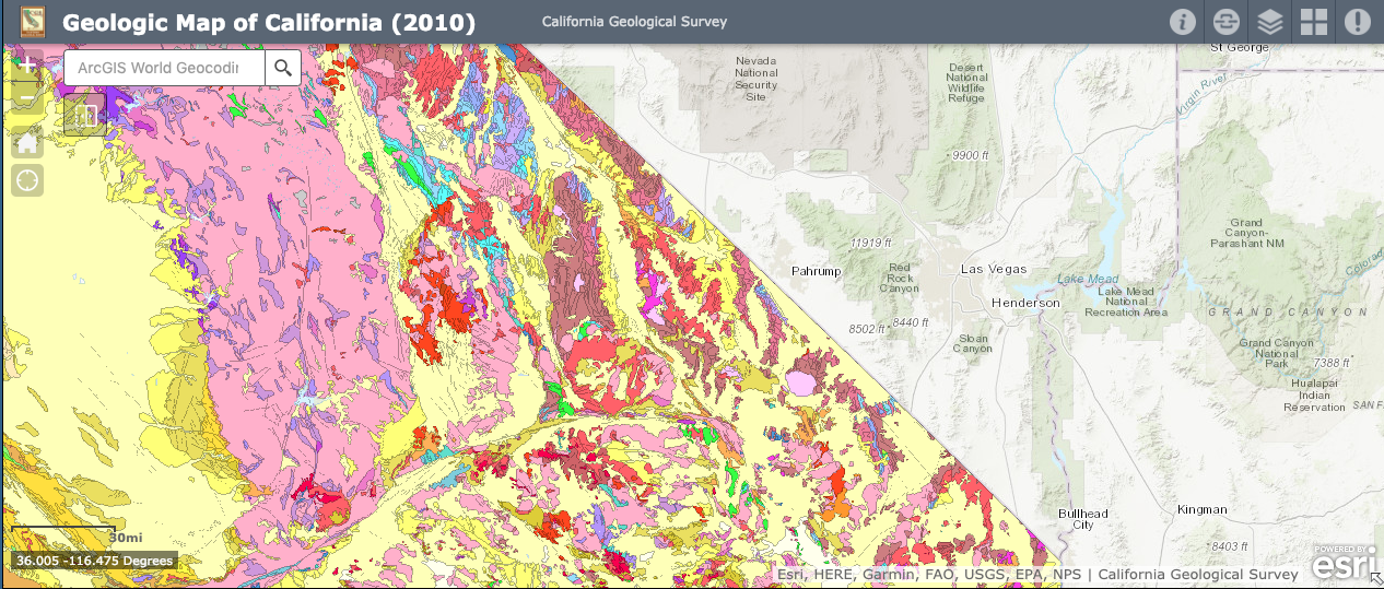
Geologic map of southern California, grabbed from the California Geological Survey. Light yellow = recent sediments. Red = recent volcanics. Pink = Mesozoic granites. Bright green and light blues = metamorphic basement.

During the Miocene, extension started up and produced both steep normal faults and shallowly dipping detachments. The geometry of these fault systems usually result in older faults rotating out of favorable orientation and new faults developing, so the current landscape includes many active and dormant normal faults. Uplifting continental blocks become mountain ranges and shed sediments into the basins between them, giving the region of extension the characteristic "Basin and Range" landforms. During recent colder and wetter times (Plio-Pleistocene), many of these valleys were filled with lakes and big glaciers in the High Sierras fed major outflowing rivers whose sediments still blanket the landscape. At the present time, the right- lateral strike-slip motion of the Pacific-North America plate boundary, which is mostly taken up on the San Andreas Fault system near the coast, has partitioned some of the motion inland producing oblique and even strike slip motion in the Eastern California Shear Zone / Walker Lane (a zone of faults along the eastern side of the Sierra Nevada). Many of these normal and strike slip faults are "leaky" - occasionally erupting small cones and flows.


Active faults in the Mojave-Las Vegas area. White circles are earthquakes during the last 12 months, scaled by magnitude (largest ~ 3.6). Image grabbed from earthquake.usgs.gov


Itinerary:

Day Activity Where we sleep Groceries? Shower?
22 Jan 17:30 First Informational Meeting, FDA 211
Weds February 20, 3:00-4:30 Discuss: Regional Overview, assign poster topics for 645 students FDA 232 (small conference room near auditorium)
Weds March 20, 3:30-5:00 Discuss: Sevier/Laramide and Basin and Range FDA 232
Weds 10 April, 1-3:30 pm Discuss: Extension and Strike-slip FDA 232
April 17 OR 19 (9:00-13:00) plus April 19 (13:00-17:00_ Orientation and skills review day at McGill: "Boot Camp" Meet at FDA
Tues 30 April Christie fly to Las Vegas
Weds 1 May Students and TAs fly to Vegas, groceries Black Canyon Group Campsite, Mojave Groceries in LV
Thurs 2 May Mojave National Preserve, start notebooks Black Canyon Group Campsite, Mojave
Fri 3 May Shop in Barstow, Calico Folds (maybe) Owl Canyon Campground Stater Bros. KOA- quick showers
Sat 4 May Introduction to Rainbow Basin and Waterman Hills, start mapping Owl Canyon Campground
Sun 5 May Rainbow Basin and Waterman Hills mapping Owl Canyon Campground
Mon 6 May Rainbow Basin and Waterman Hills mapping Travelodge by Wyndham Barstow shower + laundry
Tues 7 May Groceries; sites in Eastern Sierra/Owens Valley Grays Meadow Campsite Von's in Barstow
Weds 8 May Death Valley - Titus Canyon, Mesquite Dunes Mesquite Spring, DVNP
Thurs 9 May Little Hebe stratigraphy, Badwater, detachment SHEAR in Shoshone Yes
Fri 10 May Drive through LV, shop, set up camp at Muddy Mountain Buffington Windows (wild camp) Grocery shop
Sat 11 May Mapping Muddy Mountain Buffington Windows (wild camp)
Sun 12 May Mapping Muddy Mountain Buffington Windows (wild camp) Small shop at Moapa option to shower at Moapa Travel Plaza
Mon 13 May Mapping Muddy Mountain Buffington Windows (wild camp)
Tues 14 May Valley of Fire Valley of Fire group camp
Weds 15 May Valley of Fire Valley of Fire group camp Showers at Moapa Travel Plaza
Thurs 16 May Clean up equipment, storage, airport N/A


Helpful Links

Moon phases for May 2019 -- 3 days waxing crescent for our best stars night

Geological Field Etiquette from RocDocTravel

General Geologic History of the Mojave National Preserve (good for the area) from the USGS

What to Expect at Geology Field Camp by Eric Ferré and Emily Ferré

Probably our coldest night of the trip

Temperatures in the Mojave

Can be quite warm at Muddy Mountain

Take advice from the Bedouins on how to dress for the desert


Travel Arrangements:

Flights will leave Montreal quite early on May 1 in order to arrive in Las Vegas in time to shop and get out to our first camp. Students will be responsible for getting themselves to the airport in time to check in 2h before the international flight.

Flights will leave Las Vegas Airport after 3 pm on May 16.

Flight bookings will be coordinated by the EPS department. The department is required to book flights through the contracted university travel agency, and flights purchased by other means cannot be covered by EPS. Flights will be booked when student registration is confirmed.

Once we arrive in Las Vegas, we will travel in a convoy of rented vehicles. All transportation will be provided. Opportunities for shopping are noted on the itinerary (but if you have an urgent need, speak to prof or TA and we will find a way to help).

Check back to this section for more info!


What to Wear

Download printable packing checklist (pdf)

For field mapping on hot, sunny, possibly windy days, it's best to stay covered in light-weight clothing (long pants and sleeves preferable). In some areas the rocks and plants can be very scratchy and scrapy, so jeans are ok for cooler days. Hiking boots are essential for safety and comfort. Thick hiking socks will prevent blisters. Sun protection is essential: a broad-brimmed hat, sunglasses, and a bandana or light scarf to cover the back of your neck.

Laundry will be available on May 7 and 9. Field clothes get dirty, so it is nice to keep a set of warm sweats or something comfy to sleep in that stays clean in the tent.


What to Bring

You need a lot of things with you in the field every day. You will be taking measurements with a compass and recording them in your notebook and on the map using a protractor. You will shade in geologic units as you walk around. You will be using different pens and pencils for each purpose. Most of these items are pretty generic. The mapboard you will build yourself. It should be a stiff clipboard you can carry around all day and write on, and needs a cover that will protect your map from dust and rain and spills, which won't blow around. I will show you in informational meetings how to make one from two pieces of perspex, some duct time and binder clips. You can also use a normal clip board and a piece of perspex. The top should be transparent so that you can see the map for navigating and locating yourself without exposing the map to the elements (wind being the worst).

Download printable packing checklist (pdf)

Sleeping quarters should be pretty simple - tent, sleeping bag (a warm one), and sleeping pad. Good sleep is essential so make sure you know how to set everything up and can sleep comfortably on it BEFORE your first night in the Mojave Desert. Do not neglect a good head lamp, or more than one - for working after dark or just looking for a drink of water in the dark. If you love your pillow, bring it. We should pack light where possible but not at the cost of quality sleep. Bring a cover or bag to keep it clean though! If you don't have all the gear you need, you can rent it from the McGill Outdoors Club. Financial support for this is available, talk to Christie.

Varia - these will be organized and added to ...


Field School 1
EPSC231
Course overview

This course is designed to take your classroom and field trip experience and bring it to life in some of the most beautiful geological sites on the planet. Southern Nevada and eastern California are traditional stomping grounds for geologist training courses from all over the world, due to the variety of rock types and structural features which are well-exposed in strikingly beautiful landscapes.

This course is designed to develop your spatial perception and understanding of maps, give some hands-on experience, and increase your literacy in the methods practiced by geologists working in academia, government, and the resource industries.

Learning Outcomes

By the end of this course, students should be able to identify and describe some common types of rocks in the field, navigate on a topographic map or aerial photo, identify faults and establish their orientation and sense of motion, construct geologic maps, and construct cross sections from those maps.

Instructional Method

This course takes place entirely in the field, and all work will be completed and turned in during the field work. The areas we will study have been chosen for extraordinary exposure, interesting rocks, and appropriate levels of difficulty.

Field courses are different than classroom instruction in that they require a different set of skills. You may find yourself challenged in unexpected ways, and you may experience some discomfort, due to the broad scope of the tasks assigned and to the unfamiliar working conditions. Do not despair. Focus on the outcrop in front of you. Identify the rock, make some notes, take a strike and dip, move to the next outcrop. Soon, patterns emerge on the map which will help guide you where to go.

Support each other in the field, but take care not to become too reliant on your classmates of allow anyone to become too reliant on you. You will switch partners for each assignment (no repeating partners). There are four assignments (Valley of Fire, Ubehebe, Muddy Mountain, and Rainbow Basin) so plan your partnerships accordingly.

Course Materials

Davis and Reynolds, in their textbook Structural Geology of Rocks and Regions, included a detailed appendix of field methods information including some useful words on philosophical approaches to mapping and how to prepare. I scanned it (rather badly) for you here: D and R appendix A (selected sections). Please review this material - I will bring the textbook on the field trip as well for reference.

There are two recommended textbooks. Either one is fine, they are somewhat redundant in terms of the basics. The Freeman book is pocket-sized and handy to carry around, and contains helpful diagrams on how to take field measurements and plot them. The Compton book is a more thorough reference and will help you more in the long term if you advance to other field courses or research. It is my favorite field methods book and I am elated it is now available online.

Procedures in Field Geology (Amazon link). I have acquired spiral-bound copies directly from the author and will sell them for $20 CAD or $15 USD (cash preferred).

Geology in the Field (Amazon link). Available paperback or Kindle.

Content

This course has two main goals: to give students some experience in the fundamentals of geological mapping (thereby becoming more effective critical users of maps) and to expose students to a variety of extraordinary geology and tectonic environments. To become a very experienced mapper you will need a lot more experience, but many students will finish the course and have made very good maps under ideal conditions. The order of assignments in the course is largely controlled by geography and climate (we will do Rainbow Basin first because it is farther south and at lower elevation). Keeping a field notebook is the fundamental skill at the core of all field work - even if you never use a pencil and book again (in this digital age), this practice will teach you to write things down, how to write them down, and in sketching and describing, to take time to look at things and think about what they mean. I hope that last point is what you take away with you if nothing else - it is time consuming and may be frustrating but as scientists it is an essential skill. Refer above to the Geologic History section for more information about what we will see.

Evaluation

The course reader (distributed on May 1) will include detailed assignment sheets, instructions, and marking rubrics for all assignments. Every effort will be made to provide rapid feedback so that students have opportunity to respond and improve during the course. Marking philosophy emphasizes: hard work, problem solving, cooperation, improvement (not perfection). Accuracy is more important than completeness, but slow, accurate mappers will be expected to revise their approach to address efficiency. Fast, inaccurate mappers will be encouraged to slow down. Etc.

Assignment Value
Review Day Assignments 5%
Rainbow Basin Map 10%
Cross section 10%
Notebook and stereonets 5%
Write-up 5%
Little Hebe Strat Column 5%
Notebook 5%
Muddy Mountain Map 10%
Rock Description 10%
Notebook and stereonets 5%
Write up 5%
Valley of Fire 5%
Notebooks Daily, not including the major projects 20%


Tectonics in the Field
EPSC645
Course overview

The southwest US has experienced a continual evolution from passive margin deposition to continental shortening to extension to the present-day transition to transform motion. Complex histories require exceptional supporting observations. In this course students will enjoy a skim of the literature of field observations which have led to the development of this protracted tectonic history, and identify a particular event or geologic feature for deeper study and presentation. Students will them visit field examples of the deformation structures and learn to map these structures and extract kinematic and relative chronological data from these structures.

This course is designed to develop and reinforce field geological mapping skills at graduate level with emphasis on interpreting the observations in the tectonic context. Specific assignments will be tailored to the skill level and interests of enrolled students.


Learning Outcomes

Everyone taking this course is expected to get better at things. These things could include, but are not limited to: camping, hiking, planning, treating geological interpretations with appropriate and well-founded skepticism (also and especially applicable to other planets or areas with vegetation), reading and understanding the geological literature, talking about the ancient to recent to current tectonics of the SW US... The focus is on giving everybody the chance to improve the skills they need/want, which will be non-uniform across the class. Marking will therefore be pretty subjective and will reward: hard work, problem solving, cooperation, and improvement.


Methods of Instruction

To put it a little too simply, beginner mapping is usually in an area where you can have a pretty good idea of what the rocks looked like before anything messed them up. This includes cases of "layer cake geology" - that is, where layer after layer was deposited in a somewhat uniform fashion. Small modifications on this are also included (e.g. if the layers are wedge-shaped instead of tabular. Rainbow Basin is an example of this). Gentle deformation of the layers can be readily identified and measured, and with a little daydreaming and armwaving, and maybe a few sketches in the notebook, it is easy to "undo" the deformation in your mind and understand the initial state. More advanced mapping involves describing areas where either the initial state is too ambiguous or complex to subject itself to simplifying assumptions, or the deformation is so extreme that information on the initial state is essentially destroyed. The Waterman Hills detachment is an example of this type of exposure.

Students will be able to self-identify for the appropriate level of projects they wish to undertake. Instruction will be through readings, verbal coaching, written and verbal feedback, and practice.


Course Materials

During winter semester we will meet 3 times for 1.5 hours to discuss journal articles and textbook chapters. The readings are as follows:
February: Regional Overview and thrust systems Dickinson (2006) Geotectonic evolution of the Great Basin, Geosphere, v. 2, 7, 353-368

Boyer and Elliott (1982) Thrust Systems, American Association of Petroleum Geologists Bulletin, v. 66, n. 9, 1196-1230.

March 20, 3:30-5 pm : Shortening to extension (Sevier-Laramide and transition) Hamilton (1987) Crustal extension in the Basin and Range Province, southwestern United States. Geological Society London Special Publications 28, 155-176.

Papers of individual interest related to Cretaceous-Oligocene

At this meeting: determine topics for Field Presentations

April: Basin & Range extension and strike slip Davis & Reynolds Structural Geology of Rocks and Regions Chapter 11: Active Tectonics (selected sections on Western US, Eastern California Shear Zone, Basin and Range ... I left the Cascadia bit in there since it's only a few pages but not really important to us at this stage.)

Papers of individual interest related to Oligocene-Present

Suggested topics for field presentations: Recent Death Valley tectonics and stratigraphy:
Knott et al. 2005, Upper Neogene stratigraphy and tectonics of Death Valley - a review, Earth-Science Reviews v. 73, 1-4, 245-270.
Coso Volcanics
Cordilleran core complexes
Melissa: night sky and/or Death Valley faults
Inga: 1872 Lone Pine earthquake
Sam: Coso volcanic field / geothermal etc.
Tim: Cultural/human history of someplace


Course Content

Tectonics in the Field aims to mobilize a group of students from diverse backgrounds to read, understand, and interpret the rock record of tectonic processes. Students will participate in a monthly reading group to develop background knowledge of the tectonic history of the region we will visit (see Geologic History for a brief overview). Students will become expert on a topic of their choosing related to something we can visit, and will make a presentation to the whole group at that stop. Field assignments will be appropriate to each student's background and interests - students may participate in the undergraduate assignments but there will be substitutions available for more advanced students or those with particularly focused interests. In this first offering of the course, students will play a large role in directing the field component, thereby gaining experience relevant to research-driven field work.


Evaluation

Table is under construction; currently does not add up to 100%. Working on setting up appropriate structure for diverse group of students. One or more assignments may be replaced by opportunities to field assist for special visitor (TBD). Check back later.
Assignment Value
Participation in 3 reading discussion meetings Present at one meeting 5%
Review Day Assignments OPTIONAL No credit, come if you know you need it
Presentation in the field on your expert topic 2 page (B/W) handout due April 22 for inclusion in course reader 10%
Rainbow Basin (beginner) or Waterman Hills (advanced) Map 10%
Cross section (RB) or Structural Section (WH) 10%
Notebook and stereonets 5%
Write-up 5%
Little Hebe Strat Column 5%
Notebook 5%
Muddy Mountain Map 10%
Cross Section 10%
Notebook and stereonets 5%
Write up 5%
Notebooks Daily, not including the major projects 15%