LITHOPROBE is a scientific project of international stature and the largest Earth
science research project ever undertaken in Canada. It comprises a network of centers of
excellence involving collaborative, multidisciplinary investigations of the nature and
evolution of Earth's lithosphere beneath the Canadian landmass and surrounding oceans; it
is acclaimed by some experts as the best Earth science project of its kind in the world.
LITHOPROBE derives from "probing the lithosphere".
The present lithosphere consists of a global mosaic of plates all moving relative to one
another. The collision, separation and side-swipe motion of these plates and their
predecessors and the recycling of Earth material into new plates over billions of years
has amalgamated, sorted, compressed and modified Earth's lithosphere to form the present
continents. How this has occurred is a fundamental question of Earth-science research and
one that LITHOPROBE addresses throughout its scientific program. Knowledge of the
composition and geometry of this continental amalgam in three dimensions, and of its
evolution during the fourth dimension - time, is vital to the exploration for buried
mineral and hydrocarbon resources, and for understanding Earthquake and volcanic hazards
that occur at the surface.
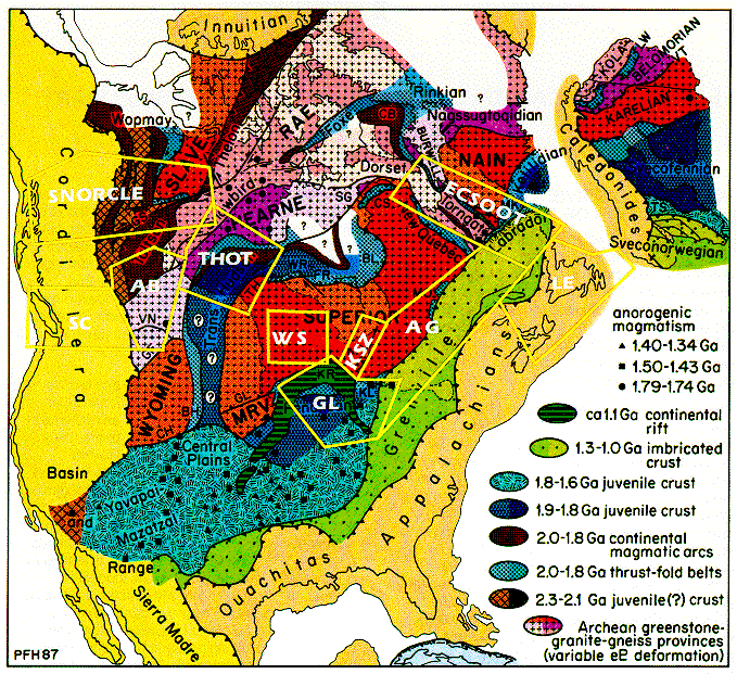
LITHOPROBE is a coordinated yet highly decentralized research program. Its principal
scientific and operational components are built around a series of transects or study
areas, each of which is focussed on carefully selected geological features of the North
American continent that represent globally significant geotectonic processes. Each
transect (in the above figure; click on figure for description and
enlargement) includes an integrated set of projects that address fundamental problems
concerning the structure and evolution of the lithosphere and are carried out by a
multidisciplinary transect team headed by a Transect
Leader(s). Together, the ten transects represent a concerted effort to develop an
enhanced understanding of how the North American continent has evolved to form the present
Canadian landmass.
The science of LITHOPROBE is spearheaded by the seismic reflection method because this
is the geophysical technique that produces the best images of boundaries between rock
units and of structures in the subsurface. In its application, the seismic reflection
method is highly complex, involving a skilled acquisition crew with millions of dollars of
equipment whether on land or at sea. On land, LITHOPROBE has been using large
truck-mounted mechanical vibrators as sources (the "Vibroseis" method) because
they are logistically appropriate and environmentally safe for the hard-rock areas
surveyed. In a typical regional survey, 240 groups of geophone
sensors are spaced at 50 m intervals over a 12 km length. Sensor outputs are recorded on a
truck-mounted computer system. High resolution surveys, for which the geological targets
are in the uppermost crust and the 240 groups are spaced at smaller intervals (10 to 20 m)
over 2 to 5 km, have been undertaken with the participation and collaboration of industry
and provincial government agencies. A description of the seismic reflection method and the
subsequent data processing can be seen at the LITHOPROBE Atlas Home
Page.
To unravel the mysteries surrounding the present structure and past evolution of the
continent requires a coordinated, multidisciplinary approach. In addition to seismic
reflection surveys, which spearhead the LITHOPROBE research, other methods applied
include:
- seismic refraction and wide-angle reflection surveys,
- gravity and magnetic studies,
- electromagnetic studies,
- heat flow and geothermal studies,
- geological mapping,
- structural geology,
- igneous and metamorphic petrology,
- stratigraphy and sedimentology,
- geochemistry,
- geochronometry, and
- paleomagnetism.
Questions or comments?
(Litho@geosci.lan.mcgill.ca)